Where: Channel | Metadata | General tab
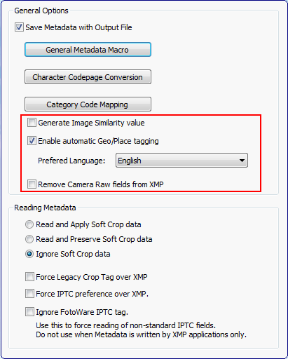
Color Factory can analyze images and create a similarity index that is stored as a 'checksum' in an XMP field. This allows FotoStation and FotoWeb to sort files by similarity. It should be noted that there is no face or shape recognition involved in this process; it is based on analyzing the color balance in the image and finding images with similar colors.
If your input images contain GPS data, Color Factory can look up the coordinates and automatically fill in a picture's Country (#101) and City (#090) fields.
Similarly, for an input file that has the Country and City fields filled in, Color Factory can do a 'reverse' lookup and fill in the GPS coordinates that correspond to the country and city specified in the metadata.
If an input file has both GPS data and country and City filled in, Color Factory does not alter the existing information.
The Preferred language setting controls which language is used for inserting city and country names in the metadata during translation of GPS coordinates.
Note:
This functionality relies on a secure HTTP connection (port 443) to the FotoWare Cloud Service, specifically places.fotoware.com.
You will also need to fill in your valid SMA number in the Operations Center to enable geotagging of pictures. See the Operations Center documentation for more information.
If you want Color Factory to strip all Camera Raw metadata from the files processed in the channel you can tick this option. This will remove all information contained in the Camera Raw namespace in the input file.
Use this option if your JPEG files inadvertently open in the Camera Raw module in Photoshop - they will do so if the files contain Camera Raw XMP data.